top of page

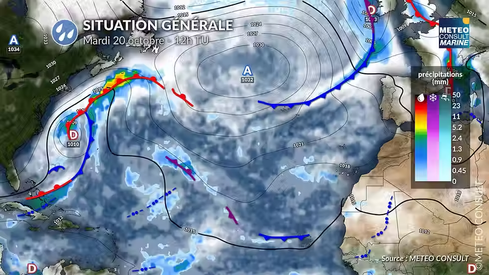
This Tuesday, irregular and disturbed westerly flow, under the influence of a 1006 hPa depression moving up from Normandy towards the south of England.

On Wednesday, after the passage of a cold front in the middle of the night, a very active trough will be observed in a strong westerly flow.

Thursday, disturbed south to southwest flow ahead of a rapidly deepening low-pressure system over the near Atlantic. At 12:00 UTC, it was located 400 miles west of Brittany at 987 hPa.

During the night from Thursday to Friday, the low-pressure system continued to deepen. It was located at 977 hPa over Cornwall, England, in the middle of the night and continued its path along the southern coast of England through the end of the night and into the morning. Southwesterly, then stormy westerly winds affected Saint-Malo and the northern coasts of Brittany between the middle of the night and Friday morning .

Weather conditions in Saint-Malo:

Tuesday 20 :

Cloudy skies in the morning with light rain or showers. Improvement in the afternoon with drier weather and the return of sunny spells.

Wind: West-northwest 15 to 25 km/h in the morning, west 20 to 30 km/h, gusts 40-45 km/h in the afternoon. Temperatures: 11°C to 15°C

Risk of precipitation: 80% in the morning, 20% in the afternoon


Wednesday 21st :

Unsettled and unstable weather conditions with alternating periods of sunshine and cloud cover, which may be accompanied by showers and strong gusts.

Wind: west, 40 to 45 km/h with gusts between 70 and 90 km/h during squalls

Temperatures: 11 to 14°C

Risk of precipitation: 90%


Thursday 22nd :

A mix of clouds and sunny spells in the morning. The sky will become very cloudy to overcast in the afternoon with light rain or showers in the late afternoon and evening, accompanied by strengthening winds. Wind: southwesterly 20 to 30 km/h, gusting to 45-50 km/h during the day, becoming southerly in the evening 30 to 40 km/h, gusting to 70 km/h.

Temperatures: from 11 to 17°C

Risk of precipitation: 10% in the morning, 40% in the afternoon, 80% in the evening.


Night of Thursday 22nd to Friday 23rd: significant strengthening of the wind with the arrival of the storm system over Cornwall, England. South then southwest winds of 50 to 55 km/h with gusts between 90 and 110 km/h by the end of the night.


Friday the 23rd :

The storm reached its peak in the morning with the wind shifting to the west and significant instability in the air mass within an active trough. The west wind blew at 55-60 km/h with maximum gusts between 100 and 120 km/h. The precise wind intensity still needs to be determined three days before the event. On Friday afternoon, as the low-pressure system moved away, the wind gradually weakened, with westerly gusts of 80 to 100 km/h in the early afternoon, then 70 to 80 km/h by the end of the day.


Further trend

Saturday 24th : The weather remains unsettled, but the west to southwest wind is significantly less strong than the previous day, with average wind speeds of 30-35 km/h and maximum gusts of around 60 km/h. The sky will be partly cloudy with some sunny spells and numerous showers in the morning. Cloud cover will increase in the afternoon with the arrival of more rain.


Sunday 25th : Unsettled weather with alternating sunny spells and cloudy periods bringing showers. Strong west to northwest winds of 40-50 km/h with gusts of 70-80 km/h under showers.


4 hours ago
3 min read

General situation

This Tuesday, irregular and disturbed westerly flow, under the influence of a 1006 hPa depression moving up from Normandy towards the south of England.

On Wednesday, after the passage of a cold front in the middle of the night, a very active trough will be observed in a strong westerly flow.

Thursday, disturbed south to southwest flow ahead of a rapidly deepening low-pressure system over the near Atlantic. At 12:00 UTC, it was located 400 miles west of Brittany at 987 hPa.

During the night from Thursday to Friday, the low-pressure system continued to deepen. It was located at 977 hPa over Cornwall, England, in the middle of the night and continued its path along the southern coast of England through the end of the night and into the morning. Southwesterly, then stormy westerly winds affected Saint-Malo and the northern coasts of Brittany between the middle of the night and Friday morning .


Weather conditions in Saint-Malo:

Tuesday 20 :

Cloudy skies in the morning with light rain or showers. Improvement in the afternoon with drier weather and the return of sunny spells.

Wind: West-northwest 15 to 25 km/h in the morning, west 20 to 30 km/h, gusts 40-45 km/h in the afternoon. Temperatures: 11°C to 15°C

Risk of precipitation: 80% in the morning, 20% in the afternoon


Wednesday 21st :

Unsettled and unstable weather conditions with alternating periods of sunshine and cloud cover, which may be accompanied by showers and strong gusts.

Wind: west, 40 to 45 km/h with gusts between 70 and 90 km/h during squalls

Temperatures: 11 to 14°C

Risk of precipitation: 90%


Thursday 22nd :

A mix of clouds and sunny spells in the morning. The sky will become very cloudy to overcast in the afternoon with light rain or showers in the late afternoon and evening, accompanied by strengthening winds. Wind: southwesterly 20 to 30 km/h, gusting to 45-50 km/h during the day, becoming southerly in the evening 30 to 40 km/h, gusting to 70 km/h.

Temperatures: from 11 to 17°C

Risk of precipitation: 10% in the morning, 40% in the afternoon, 80% in the evening.


Night of Thursday 22nd to Friday 23rd: significant strengthening of the wind with the arrival of the storm system over Cornwall, England. South then southwest winds of 50 to 55 km/h with gusts between 90 and 110 km/h by the end of the night.


Friday the 23rd :

The storm reached its peak in the morning with the wind shifting to the west and significant instability in the air mass within an active trough. The west wind blew at 55-60 km/h with maximum gusts between 100 and 120 km/h. The precise wind intensity still needs to be determined three days before the event. On Friday afternoon, as the low-pressure system moved away, the wind gradually weakened, with westerly gusts of 80 to 100 km/h in the early afternoon, then 70 to 80 km/h by the end of the day.


Further trend

Saturday 24th : The weather remains unsettled, but the west to southwest wind is significantly less strong than the previous day, with average wind speeds of 30-35 km/h and maximum gusts of around 60 km/h. The sky will be partly cloudy with some sunny spells and numerous showers in the morning. Cloud cover will increase in the afternoon with the arrival of more rain.


Sunday 25th : Unsettled weather with alternating sunny spells and cloudy periods bringing showers. Strong west to northwest winds of 40-50 km/h with gusts of 70-80 km/h under showers.


bottom of page